
Endless Landscapes and Too Little Information
There are a few guidebooks out there that help us with routes, trailheads, junctions, and some route descriptions. There are also a few websites that support hiking, biking, and exploring wilderness areas. But, they only cover 1% of the available routes in an area like the Interior of B.C.
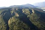
Pick any area in the Interior. For example, I started the process of trying to understand the Ptarmigan Hills-Spa Hills -Fly Hills area. The area includes all the numerous hills, ridges, and valleys, Mount Chase, Mount Tappen, 7 lakes, and 4 main access roads. How do we find out what opportunities there are?
In the case of this area, there is a very tiny bit of information about hiking, more information about snowmobiling and 4WD/dirtbiking/quadding, some basic fishing information, and bit about the access roads. Its a big area – about 600 sq. km. It would take weeks to explore all the areas. In spite of it being right on the border of a city (Salmon Arm), in print or on websites, there is less than 2 pages of information available (and that includes photos)!  From my research, I found that some of the printed maps are not accurate or out-of-date.
It is our responsibility to explore and then share the information, but in providing this, it is also our responsibility to encourage responsible access to each new area we choose to “introduce.”
